tram
(m)
acumulat
en pujada
acumulat
en baixada
| GR 10, 4t any | |||||||||||||||||
| Juny-juliol de 2019 | |||||||||||||||||
| Temps acumulat: 44,0 hores | El Tango | ||||||||||||||||
| Desnivell acumulat en pujada: 6.250 metres | Velocitat estimada en pla: 3,4 km/h | Fotos i tracks | |||||||||||||||
| Desnivell acumulat en baixada: 6.469 metres | |||||||||||||||||
| Distància: 110,9 kms | Velocitat estimada en alçada: 240 m/h | ||||||||||||||||
| Dia amb enllaç als tracks | Lloc (amb enllaç al temps que farà) | Altura (metres) | Desniv. tram (m) |
Desniv acumulat en pujada |
Desniv acumulat en baixada |
Segons càlcul: temps tram (hores) | Segons càlcul: temps acumulat (hores) | Kms | Kms acumul. | Gràfic d'altituds | |||||||
| 25-6 | De Barcelona a Gourette | ||||||||||||||||
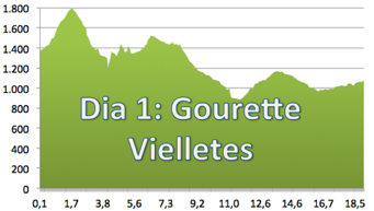
| 26-6 | Gourette — Hotel Amoulat | 1.346 |
|
||||||||||||||
| Caperan de Tortes | 1.792 | 446 | 446 | 0 | 1:51 h | 1:51 h | 1,710 | 1,710 | |||||||||
| Carretera | 1.167 | -625 | 446 | -625 | 0:43 h | 2:34 h | 2,440 | 4,150 | |||||||||
| Punt 1732 | 1.732 | 565 | 1.011 | -625 | 2:21 h | 4:55 h | 2,400 | 6,550 | |||||||||
| Chapelle de Pouey Laun | 830 | -902 | 1.011 | -1.527 | 1:30 h | 6:25 h | 5,100 | 11,650 | |||||||||
| Chemin de la Monyoye | 1.185 | 355 | 1.366 | -1.527 | 1:28 h | 7:54 h | 2,640 | 14,290 | |||||||||
| Estaing | 912 | -273 | 1.366 | -1.800 | 0:32 h | 8:27 h | 1,840 | 16,130 | |||||||||
| Viellettes — Gîte Les Viellettes | 1.075 | 163 | 1.529 | -1.800 | 0:48 h | 9:15 h | 2,720 | 18,850 | |||||||||
| Segons Wikiloc | 1.473 | -1.770 | 7:30 h | 22,000 | |||||||||||||
| Segons Garmin Base Camp | 1.511 | -1.808 | 18,850 | ||||||||||||||
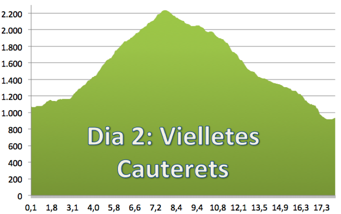
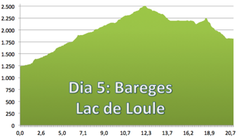
| 27-6 | Lac Loule | 1.150 | 75 | 75 | 0 | 0:30 h | 0:30 h | 1,747 | 1,747 | ||||||||
| Punt 1850 | 1.850 | 700 | 775 | 0 | 2:55 h | 3:25 h | 4,463 | 6,210 | |||||||||
| Punt 2240 | 2.240 | 390 | 1.165 | 0 | 1:37 h | 5:03 h | 1,519 | 7,729 | |||||||||
| Refuge d'Iléou | 1.984 | -256 | 1.165 | -256 | 0:41 h | 5:44 h | 2,352 | 10,081 | |||||||||
| Punt 1700 | 1.700 | -284 | 1.165 | -540 | 0:31 h | 6:16 h | 1,796 | 11,877 | |||||||||
| Punt 1400 | 1.400 | -300 | 1.165 | -840 | 0:37 h | 6:54 h | 2,146 | 14,023 | |||||||||
| Chemin du Cambasque | 1.280 | -120 | 1.165 | -960 | 0:28 h | 7:23 h | 1,624 | 15,647 | |||||||||
| Gave d'Iléou (riuet) | 1.140 | -140 | 1.165 | -1.100 | 0:16 h | 7:39 h | 0,916 | 16,563 | |||||||||
| Cauterets — Gîte Beau Soleil | 913 | -227 | 1.165 | -1.327 | 0:24 h | 8:04 h | 1,410 | 17,973 | |||||||||
| Segons Wikiloc | 1.193 | -1.327 | ?? | 18,380 | |||||||||||||
| Segons Garmin Base Camp | 1.263 | -1.397 | 17,973 | ||||||||||||||
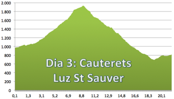
| 28-6 | Chalet Reina Hortensia | 1.278 | 365 | 365 | 0 | 1:31 h | 1:31 h | 4,300 | 4,300 | ||||||||
| Col de Rieu | 1.756 | 478 | 843 | 0 | 1:59 h | 3:30 h | 3,300 | 7,600 | |||||||||
| Punt més alt | 1.932 | 176 | 1.019 | 0 | 0:44 h | 4:14 h | 1,400 | 9,000 | |||||||||
| Bayese | 1.459 | -473 | 1.019 | -473 | 1:08 h | 5:23 h | 3,900 | 12,900 | |||||||||
| Grust | 1.006 | -453 | 1.019 | -926 | 1:00 h | 6:23 h | 3,400 | 16,300 | |||||||||
| Museu del Molí | 838 | -168 | 1.019 | -1.094 | 0:19 h | 6:42 h | 1,100 | 17,400 | |||||||||
| Mauoubèze | 722 | -116 | 1.019 | -1.210 | 0:31 h | 7:14 h | 1,800 | 19,200 | |||||||||
| Luz St Sauveur — Hôtel des Cimes | 711 | -11 | 1.019 | -1.221 | 0:38 h | 7:53 h | 2,200 | 21,400 | |||||||||
| Segons Wikiloc | 1.182 | -1.320 | ± 7:00 h | 22,900 | |||||||||||||
| Segons Garmin Base Camp | 1.196 | -1.348 | 21,400 | ||||||||||||||
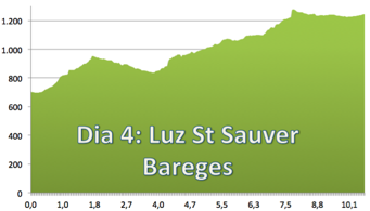
| 29-6 | Punt 950 | 950 | 239 | 239 | 0 | 0:59 h | 0:59 h | 1,800 | 1,800 | ||||||||
| Coutrades | 835 | -115 | 239 | -115 | 0:35 h | 1:35 h | 2,030 | 3,830 | |||||||||
| Hounta | 998 | 163 | 402 | -115 | 0:40 h | 2:16 h | 1,150 | 4,980 | |||||||||
| Gîte de Saint Justin | 1.278 | 280 | 682 | -115 | 1:10 h | 3:26 h | 2,680 | 7,660 | |||||||||
| Soueres | 1.235 | -43 | 682 | -158 | 0:24 h | 3:50 h | 1,380 | 9,040 | |||||||||
| Avenue Louvo | 1.225 | -10 | 682 | -168 | 0:18 h | 4:09 h | 1,070 | 10,110 | |||||||||
| Barèges — Gîte Oasis | 1.244 | 19 | 701 | -168 | 0:06 h | 4:15 h | 0,340 | 10,450 | |||||||||
| Segons Wikiloc | 677 | -205 | 4:26 h | 10,650 | |||||||||||||
| Segons Garmin Base Camp | 820 | -278 | 10,450 | ||||||||||||||
| 30-6 | Tournaboup | 1.447 | 203 | 203 | 0 | 0:52 h | 0:52 h | 3,000 | 3,000 | ||||||||
| Pont de Pontou | 1.740 | 293 | 496 | 0 | 1:13 h | 2:06 h | 2,700 | 5,700 | |||||||||
| Aigües Cluses | 2.100 | 360 | 856 | 0 | 1:30 h | 3:36 h | 3,400 | 9,100 | |||||||||
| Col de Madamete | 2.508 | 408 | 1.264 | 0 | 1:42 h | 5:18 h | 3,000 | 12,100 | |||||||||
| Lac d'Aumar | 2.194 | -314 | 1.264 | -314 | 0:35 h | 5:53 h | 2,000 | 14,100 | |||||||||
| Punt 2.249 | 2.249 | 55 | 1.319 | -314 | 1:15 h | 7:09 h | 4,300 | 18,400 | |||||||||
| Lac de l'Oule — Refuge de l'Oule | 2.015 | -234 | 1.319 | -548 | 0:47 h | 7:57 h | 2,700 | 21,100 | |||||||||
| Segons Wikiloc | 1.445 | -877 | 8:31 h | 21,900 | |||||||||||||
| Segons Garmin Base Camp | 1.522 | -950 | 21,100 | ||||||||||||||
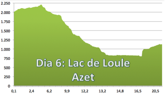
| 1-7 | Punt 2.205 | 2.205 | 190 | 190 | 0 | 1:15 h | 1:15 h | 4,300 | 4,300 | ||||||||
| Museu de la mina | 911 | -1.294 | 190 | -1.294 | 2:37 h | 3:52 h | 8,900 | 13,200 | |||||||||
| Parking du Stade | 829 | -82 | 190 | -1.376 | 0:31 h | 4:24 h | 1,800 | 15,000 | |||||||||
| Fournil | 827 | -2 | 190 | -1.378 | 0:19 h | 4:44 h | 1,100 | 16,100 | |||||||||
| Camping d'Autan | 800 | -27 | 190 | -1.405 | 0:26 h | 5:10 h | 1,500 | 17,600 | |||||||||
| Stensan | 997 | 197 | 387 | -1.405 | 0:49 h | 5:59 h | 1,800 | 19,400 | |||||||||
| Azet — La Bergerie | 1.127 | 130 | 517 | -1.405 | 0:32 h | 6:32 h | 1,700 | 21,100 | |||||||||
| Segons Wikiloc | 572 | -1.452 | 8:45 h | 21,370 | |||||||||||||
| Segons Garmin Base Camp | 645 | -1.533 | 21,100 | ||||||||||||||
| 2-7 | Amb cotxe: Saint Lary Soulan-Barcelona | ||||||||||||||||
| Güeps interessants: | |||||||||||||||||
| http://www.pyreneanway.com/french-pyrenees-gr-10-walk-guide/?lang=en# | |||||||||||||||||
| https://ca.wikipedia.org/wiki/GR_10_(Fran%C3%A7a) | |||||||||||||||||
| http://www.gr10-pyrenees.com/index.php | |||||||||||||||||
| Del Cantabrico al Mediterraneo por el gr10 francés | |||||||||||||||||
| https://www.larebenne.com/fr/randonnee-gr10-cauterets-bagneres-luchon-partie-4 | |||||||||||||||||
| http://gr10-hendaye-banyuls.blogspot.com.es/p/les-etapes.html | |||||||||||||||||
| http://randonnee.tourisme64.com/grands-itineraires/gr10/gr10-cote-montagne-bearnaise/ | |||||||||||||||||